![](/images/other/stat-length.png)
![Excursión Senderismo Le Tilleul - Etretat - Photo](https://media.geolcdn.com/t/1900/400/ext.pjpeg?maxdim=2&url=https%3A%2F%2Fstatic1.geolcdn.com%2Fsiteimages%2Fupload%2Ffiles%2F1553511878bg_sport_marche.png)
Etretat
AACLARANDO
Usuario
![Longitud](/images/other/stat-length.png)
Longitud
15,6 km
![Altitud máxima](https://static1.geolcdn.com/siteimages/upload/files/1508320355ic_sort_altitude_max_24dp.png)
Altitud máxima
108 m
![Desnivel positivo](https://static1.geolcdn.com/siteimages/upload/files/1508320355ic_sort_den_pos_24dp.png)
Desnivel positivo
316 m
![Km-Effort](/images/other/stat-length.png)
Km-Effort
19,8 km
![Altitud mínima](https://static1.geolcdn.com/siteimages/upload/files/1508320355ic_sort_altitude_min_24dp.png)
Altitud mínima
5 m
![Desnivel negativo](https://static1.geolcdn.com/siteimages/upload/files/1508320355ic_sort_den_neg_24dp.png)
Desnivel negativo
316 m
![Boucle](https://static1.geolcdn.com/siteimages/upload/files/16400158638029165_repeat_loop_refresh_sync_direction_icon.png)
Boucle
Sí
Fecha de creación :
2023-04-13 09:00:27.603
Última modificación :
2023-04-13 09:05:42.111
![Senderismo](https://static1.geolcdn.com/sitytour/trail-icons/101.png)
4h30
Dificultad : Muy difícil
![Escanee este código QR para abrir la excursión en la aplicación SityTrail](https://capi.geolives.com/qq0zvz2zws4bq2lad0pu/sitytour/trails/3619606/qr.png?size=200)
Aplicación GPS de excursión GRATIS
A propósito
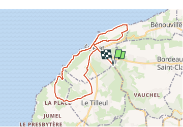
Ruta Senderismo de 15,6 km a descubrir en Normandía, Sena-Marítimo, Le Tilleul. Esta ruta ha sido propuesta por AACLARANDO.
Descripción
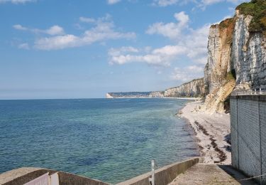
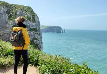
départ sur parking près du camping. Rejoindre la valleuse du Tilleul par la Valaine, puis Etretat par le golfe. Se diriger vers Bénouville par la falaise, puis revenir au point de départ en passant par le centre d'Etretat.
Localización
País:
France
Región :
Normandía
Departamento/provincia :
Sena-Marítimo
Municipio :
Le Tilleul
Localidad:
Unknown
Salida:(Dec)
Salida:(UTM)
299263 ; 5508957 (31U) N.
Comentarios
Excursiones cerca
![Excursión Senderismo Étretat - étretat golf - Photo](https://media.geolcdn.com/t/375/260/ext.jpg?maxdim=2&url=https%3A%2F%2Fservices.sitytrail.com%2FGeolivesWS%2FDownloadMedia.ashx%3FTrailID%3D302991%26Media%3Dfix__20140518154039.jpg)
![Senderismo Senderismo](https://static1.geolcdn.com/sitytour/trail-icons/101.png)
étretat golf
Senderismo
Fácil
(1)
Étretat,
Normandía,
Sena-Marítimo,
France
![](/images/other/stat-length.png)
4,7 km | 6,7 km-effort
1h 42min
![](https://static1.geolcdn.com/siteimages/upload/files/16400158638029165_repeat_loop_refresh_sync_direction_icon.png)
Sí
![Excursión Senderismo Étretat - Le sentier nature des falaises d'Etretat - Photo](https://media.geolcdn.com/t/375/260/ext.jpg?maxdim=2&url=https%3A%2F%2Fservices.sitytrail.com%2FGeolivesWS%2FDownloadMedia.ashx%3FTrailID%3D172695%26Media%3D14074_5.jpg)
![Senderismo Senderismo](https://static1.geolcdn.com/sitytour/trail-icons/101.png)
Le sentier nature des falaises d'Etretat
Senderismo
Medio
(2)
Étretat,
Normandía,
Sena-Marítimo,
France
![](/images/other/stat-length.png)
9,3 km | 12,7 km-effort
3h 30min
![](https://static1.geolcdn.com/siteimages/upload/files/16400158638029165_repeat_loop_refresh_sync_direction_icon.png)
Sí
![Excursión Bici de montaña Étretat - Etretat Yport - Photo](https://media.geolcdn.com/t/375/260/ext.jpg?maxdim=2&url=https%3A%2F%2Fservices.sitytrail.com%2FGeolivesWS%2FDownloadMedia.ashx%3FTrailID%3D104928%26Media%3D8466_1.jpg)
![Bici de montaña Bici de montaña](https://static1.geolcdn.com/sitytour/trail-icons/202.png)
Etretat Yport
Bici de montaña
Difícil
(4)
Étretat,
Normandía,
Sena-Marítimo,
France
![](/images/other/stat-length.png)
35 km | 43 km-effort
3h 0min
![](https://static1.geolcdn.com/siteimages/upload/files/16400158638029165_repeat_loop_refresh_sync_direction_icon.png)
Sí
![Excursión Senderismo Le Tilleul - La Valleuse d'Antifer - Photo](https://media.geolcdn.com/t/375/260/5e0af125-3ee6-4ef5-8573-7b5656fc4a5d.jpg&format=jpg&maxdim=2)
![Senderismo Senderismo](https://static1.geolcdn.com/sitytour/trail-icons/101.png)
La Valleuse d'Antifer
Senderismo
Difícil
(1)
Le Tilleul,
Normandía,
Sena-Marítimo,
France
![](/images/other/stat-length.png)
12,5 km | 16,3 km-effort
3h 42min
![](https://static1.geolcdn.com/siteimages/upload/files/16400158638029165_repeat_loop_refresh_sync_direction_icon.png)
Sí
![Excursión Senderismo La Poterie-Cap-d'Antifer - Etretat - Photo](https://media.geolcdn.com/t/375/260/ext.jpg?maxdim=2&url=https%3A%2F%2Fstatic1.geolcdn.com%2Fsiteimages%2Fupload%2Ffiles%2F1553511878bg_sport_marche.png)
![Senderismo Senderismo](https://static1.geolcdn.com/sitytour/trail-icons/101.png)
Etretat
Senderismo
Fácil
(1)
La Poterie-Cap-d'Antifer,
Normandía,
Sena-Marítimo,
France
![](/images/other/stat-length.png)
10,6 km | 14,4 km-effort
3h 8min
![](https://static1.geolcdn.com/siteimages/upload/files/16400158638029165_repeat_loop_refresh_sync_direction_icon.png)
Sí
![Excursión Senderismo Étretat - Etretat les falaises - Photo](https://media.geolcdn.com/t/375/260/ext.jpg?maxdim=2&url=https%3A%2F%2Fstatic1.geolcdn.com%2Fsiteimages%2Fupload%2Ffiles%2F1553511878bg_sport_marche.png)
![Senderismo Senderismo](https://static1.geolcdn.com/sitytour/trail-icons/101.png)
Etretat les falaises
Senderismo
Fácil
(1)
Étretat,
Normandía,
Sena-Marítimo,
France
![](/images/other/stat-length.png)
7,6 km | 10,2 km-effort
2h 56min
![](https://static1.geolcdn.com/siteimages/upload/files/16400158638029165_repeat_loop_refresh_sync_direction_icon.png)
Sí
![Excursión Senderismo Étretat - GR21 Etretat à Fécamp - Photo](https://media.geolcdn.com/t/375/260/ext.jpg?maxdim=2&url=https%3A%2F%2Fstatic1.geolcdn.com%2Fsiteimages%2Fupload%2Ffiles%2F1553511878bg_sport_marche.png)
![Senderismo Senderismo](https://static1.geolcdn.com/sitytour/trail-icons/101.png)
GR21 Etretat à Fécamp
Senderismo
Fácil
(1)
Étretat,
Normandía,
Sena-Marítimo,
France
![](/images/other/stat-length.png)
16,4 km | 21 km-effort
4h 42min
![](https://static1.geolcdn.com/siteimages/upload/files/16400158638029165_repeat_loop_refresh_sync_direction_icon.png)
No
![Excursión Senderismo Vattetot-sur-Mer - vattetot - yport - Photo](https://media.geolcdn.com/t/375/260/66be9f19-29f6-4699-afaa-43c281fab658.jpg&format=jpg&maxdim=2)
![Senderismo Senderismo](https://static1.geolcdn.com/sitytour/trail-icons/101.png)
vattetot - yport
Senderismo
Medio
Vattetot-sur-Mer,
Normandía,
Sena-Marítimo,
France
![](/images/other/stat-length.png)
10,3 km | 13,2 km-effort
2h 29min
![](https://static1.geolcdn.com/siteimages/upload/files/16400158638029165_repeat_loop_refresh_sync_direction_icon.png)
Sí
![Excursión Senderismo Bénouville - L'aiguille de Belval - Photo](https://media.geolcdn.com/t/375/260/e5015acf-207d-4f0a-9245-b6a712853198.jpg&format=jpg&maxdim=2)
![Senderismo Senderismo](https://static1.geolcdn.com/sitytour/trail-icons/101.png)
L'aiguille de Belval
Senderismo
Medio
Bénouville,
Normandía,
Sena-Marítimo,
France
![](/images/other/stat-length.png)
9 km | 11,1 km-effort
2h 31min
![](https://static1.geolcdn.com/siteimages/upload/files/16400158638029165_repeat_loop_refresh_sync_direction_icon.png)
Sí